Loading...
Searching...
No Matches
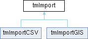
tmImport Class Reference
Inheritance diagram for tmImport:
Public Member Functions | |
| virtual bool | Open (const wxFileName &filename) |
| virtual bool | IsOk () |
| virtual bool | Import (DataBaseTM *database, PrjDefMemManage *prj, wxProgressDialog *progress=nullptr) |
| virtual bool | GetExistingAttributeValues (const wxString &attName, wxArrayString &values) |
| const wxFileName | GetFileName () const |
| const tmImportFileType | GetFileType () const |
| const TM_GIS_SPATIAL_TYPES | GetGeometryType () const |
| const long | GetFeatureCount () const |
| const int | GetFieldCount () const |
| virtual bool | GetFieldNames (wxArrayString &Fields) |
| const TOC_GENERIC_NAME | GetTarget () const |
| void | SetTarget (TOC_GENERIC_NAME value) |
| virtual wxArrayInt | GetTargetSupported () |
| virtual wxArrayString | GetTargetSupportedName () |
| void | SetLayerName (const wxString &value) |
| wxString | GetLayerName () |
| void | SetFieldKind (const wxString &value) |
| wxString | GetFieldKind () |
| void | SkipObjectKind (const wxString &fileKind) |
| void | AddObjectKindMatch (const wxString &fileKind, const wxString &dbKind) |
| void | ClearObjectKindMatches () |
| void | AddAttributeMatch (const wxString &fileAttribute, const wxString &dbAttribute, PRJDEF_FIELD_TYPE type) |
| void | ClearAttributeMatches () |
| void | AddEnumerationMatch (const wxString &attributeName, const wxString &fileEnum, const wxString &dbEnum) |
| void | ClearEnumerationMatches () |
| int | GetAttributesMatchesCount () const |
| bool | AttributeIsEnum (int index) const |
| wxString | GetAttributeNameInDB (int index) const |
| wxString | GetAttributeNameInFile (int index) const |
| bool | HasEnumAttributes () const |
Protected Member Functions | |
| bool | ShouldSkipObjectKind (const wxArrayString &fileValues) |
| bool | SetObjectKind (DataBaseTM *database, PrjDefMemManage *prj, const wxArrayString &fileValues, const wxArrayLong &oids) |
| bool | SetAttributes (DataBaseTM *database, PrjDefMemManage *prj, const wxArrayString &fileValues, wxArrayLong &oids) |
The documentation for this class was generated from the following files:
- /github/workspace/src/gis/tmimport.h
- /github/workspace/src/gis/tmimport.cpp