Loading...
Searching...
No Matches
tmGISDataRasterJPEG Class Reference
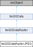
Inheritance diagram for tmGISDataRasterJPEG:

Public Member Functions | |
| virtual wxString | GetDataSizeAsHtml (int iPrecision=2) |
| Get Size of The Jpeg raster. | |
 Public Member Functions inherited from tmGISDataRaster Public Member Functions inherited from tmGISDataRaster | |
| virtual bool | Open (const wxString &filename, bool bReadWrite=TRUE) |
| Generic open code. | |
| void | UseExisting (const wxString &filename, GDALDatasetH hdst) |
| virtual tmRealRect | GetMinimalBoundingRectangle () |
| virtual TM_GIS_SPATIAL_TYPES | GetSpatialType () |
| virtual bool | SetSpatialFilter (tmRealRect filter, int type) |
| Define the area of interest. | |
| virtual bool | IsImageInsideVisibleArea () |
| Should we load image data. | |
| virtual CPLErr | GetImageData (unsigned char **imgbuf, unsigned int *imglen, unsigned char **maskbuf, unsigned int *masklen, wxSize imgSize) |
| Extract image data. | |
| bool | GetImageTranslucency (wxSize imgSize, int translucencypercent, unsigned char **alphachn) |
| Return the buffer corresponding to an alpha channel with specified translucency. | |
| virtual tmRealRect | GetImageClipedCoordinates () |
| virtual int | GetBandCount () |
| Getting number of band. | |
| virtual int | GetPyramidsInfo (wxArrayString *pyramids=nullptr) |
| Get info about pyramids. | |
| virtual wxString | GetMetaDataAsHtml () |
| Get Metadata information well formated. | |
| wxString | GetBandMetaData () |
| Getting number of band formatted as html. | |
| wxString | GetUnitMetaData () |
| Get Informations about Unit formatted for html. | |
| wxString | GetPyramidsMetadata () |
| Getting pyramids info as html string. | |
| wxString | GetImagePxSizeMetadata () |
| Get Pixels width and height. | |
| virtual bool | CreateSpatialIndex (GDALProgressFunc progress, void *pfProgressData) |
| virtual int | IsRaster () |
 Public Member Functions inherited from tmGISData Public Member Functions inherited from tmGISData | |
| tmGISData () | |
| Constructor. | |
| ~tmGISData () | |
| Destructor. | |
| int | GetDataType () |
| void | SetCoordConvert (tmCoordConvert *coordconvert) |
| tmCoordConvert * | GetCoordConvert () |
| virtual bool | Close () |
| wxString | GetShortFileName () |
| wxString | GetFullFileName () |
| virtual wxArrayLong * | SearchData (const tmRealRect &rect, int type) |
| virtual wxArrayLong * | GetAllData () |
| virtual bool | GetSnapCoord (const wxRealPoint &clickpt, double buffersize, wxArrayRealPoints &snapppts, int snaptype) |
| virtual bool | IsPointSnapped (const wxRealPoint &point, int snaptype, long excludeoid=wxNOT_FOUND) |
Additional Inherited Members | |
 Static Public Member Functions inherited from tmGISDataRaster Static Public Member Functions inherited from tmGISDataRaster | |
| static void | InitGISDriversRaster () |
| static wxString | GetAllRasterGISFormatsWildcards () |
| static tmGISDataRaster * | CreateGISRasterBasedOnType (const int &gis_format_index) |
| static tmGISDataRaster * | CreateGISRasterBasedOnExt (const wxString &extension) |
 Static Public Member Functions inherited from tmGISData Static Public Member Functions inherited from tmGISData | |
| static void | InitGISDrivers (bool bRaster=TRUE, bool bVector=TRUE) |
| Init the GDAL / OGR driver. | |
| static wxString | GetAllSupportedGISFormatsWildcards () |
| Return all supported formats. | |
| static wxArrayString | GetAllSupportedGISFormatsExtensions () |
| Returning all extensions in an array string. | |
| static tmGISData * | CreateGISBasedOnType (const int &gis_format_index) |
| Create an object of the specified format. | |
| static tmGISData * | CreateGISBasedOnExt (const wxString &extension) |
| static tmGISData * | LoadLayer (tmLayerProperties *layerprop) |
| Call this function for loading a layer. | |
| static void | EnableLogging (bool enable=true) |
| static bool | IsLoggingEnabled () |
 Protected Member Functions inherited from tmGISDataRaster Protected Member Functions inherited from tmGISDataRaster | |
| wxSize | GetImagePxDim () |
| Get Image dimensions in Pixels. | |
| bool | GetImagePxSize (double &pxsizeX, double &pxsizeY, const tmRealRect &imgrealcoord=tmRealRect(0, 0, 0, 0)) |
| Return width and height of pixels in real units. | |
| wxRect | ConvertClipedImage (const tmRealRect &origin, const tmRealRect &clipped) |
| Convert clipped Real size to image pixels size. | |
| void * | ReadImageData (GDALRasterBand *gdalBand, const wxRect &imgfilter, const wxSize &imgSize, int &buffsize) |
| Reading image data based on GDAL type. | |
| double | ReadGDALValueToDouble (void *data, GDALDataType type, int index) |
| Getting double value from data returned by GDAL. | |
| bool | GetStatMinMaxNoDataValue (double &dmin, double &dmax, double &dnodata) |
| Returning min - max - nodata stat. | |
 Protected Member Functions inherited from tmGISData Protected Member Functions inherited from tmGISData | |
| wxString | GetMinimalBoundingRectangleAsHtml (int iprecision=2) |
| Get Minimal bounding rectangle as html. | |
 Protected Attributes inherited from tmGISDataRaster Protected Attributes inherited from tmGISDataRaster | |
| GDALDataset * | m_DataSet |
| GDALRasterBand * | m_RasterBand |
| wxString | m_FileType |
| wxRect | m_PxImgFilter |
| tmRealRect | m_RasterExtent |
| tmRealRect | m_ClippedCoord |
| wxArrayString | m_RotationName |
| wxArrayShort | m_RotationStatus |
 Protected Attributes inherited from tmGISData Protected Attributes inherited from tmGISData | |
| int | m_ClassType |
Member Function Documentation
◆ GetDataSizeAsHtml()
|
virtual |
Get Size of The Jpeg raster.
- Parameters
-
iPrecision The number of digits required (default is 2)
- Returns
- An html compliant string containing the Jpeg size in an human readable format
- Date
- 24 October 2008
Reimplemented from tmGISData.
The documentation for this class was generated from the following files:
- /github/workspace/src/gis/tmgisdatarasterjpeg.h
- /github/workspace/src/gis/tmgisdatarasterjpeg.cpp